Geology
Mexican Congress hears UFOs with ‘alien’ bodies

(Reuters). Mexico’s first congressional UFO hearing featured “we are not alone” and alleged non-human remains.
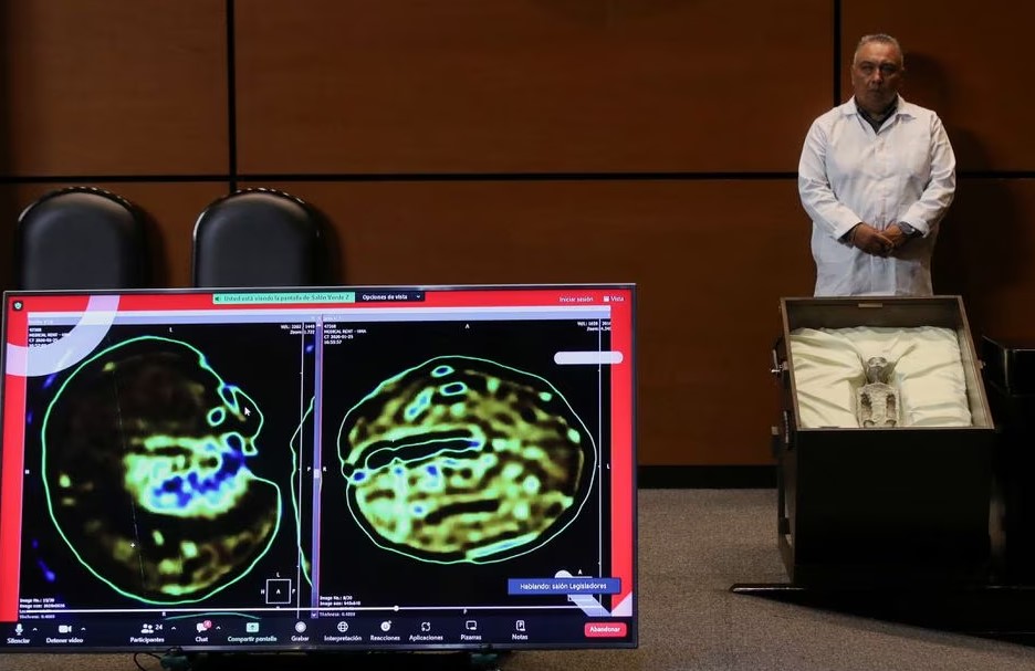
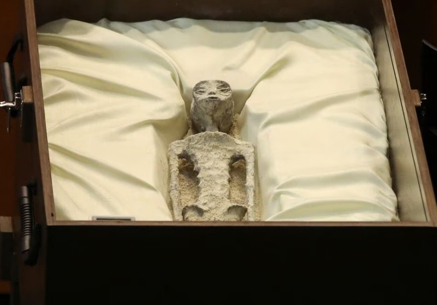
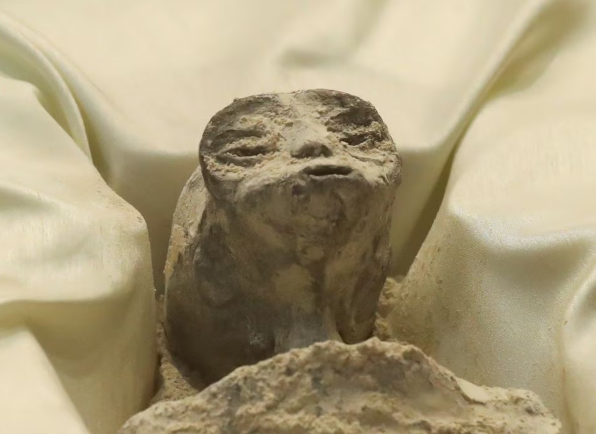
Politicians were shown two artifacts that Mexican journalist and longtime UFO enthusiast Jaime Maussan claimed were extraterrestrial corpses at the Tuesday hearing on FANI.
Maussan said The specimens were unrelated to Earthly life.
Two tiny “bodies,” displayed in cases, have elongated heads and three fingers each. Maussan said they were found in Peru near Nazca Lines in 2017. He estimated their age at 1,000 years using Mexico’s National Autonomous University’s carbon dating.
Mummified children were once found.
Maussan presented such evidence first.
“I think there is a clear demonstration that we are dealing with non-human specimens that are NOT related to any other species in our world and that any scientific institution can investigate it,” Maussan said.
“We are not alone,” he said.
“I can affirm that these bodies have no relation to human beings.”
Thursday, UNAM republished a 2017 statement saying its National Laboratory of Mass Spectrometry with Accelerators (LEMA) only wanted sample ages.
“In no case do we make conclusions about said samples’ origin,” it said.
Congress heard from former Navy pilot Ryan Graves about UAP sightings and the stigma of reporting them.
Sergio Gutierrez, a Morena congressman for President Andres Manuel Lopez Obrador, hoped the hearing would be the first of many in Mexico.
“We are left with reflections, concerns, and how to continue discussing this,” Gutierrez said.
Recent years have seen the U.S. government release UAP data after decades of denial. In recent years, NASA’s first independent UFO panel and the Pentagon have investigated military aviator sightings.
NASA will discuss study results Thursday.
Skeptics slammed Maussan’s Wednesday presentation.
“This could really hurt efforts to take the issue seriously,” tweeted. “Why didn’t they publish it after a scientific paper?”
X-rays, 3-D reconstruction, and DNA analysis were done on the remains, according to Mexican navy Scientific Institute for Health Director Jose de Jesus Zalce Benitez.

Biology
A new study shows that the Atlantic Gulf Stream was surprisingly strong during the last ice age
The world was stuck in a big ice age 20,000 years ago. Ice sheets that were two miles thick covered a large portion of North America, Scandinavia, and the British Isles.
Greenhouse gas levels were much lower, it was 6 °C colder, and the sea level was at least 120 meters lower because of all the water trapped in ice sheets. This made the land that is now underwater visible. From France to London, you could have walked through Doggerland. From Russia to Alaska, you could have walked through Beringia.
But our study, which is now out in Nature, has found at least one surprising thing about the climate during the ice age: the Gulf Stream, which moves warm water north through the Atlantic, was stronger and deeper than it is now.
As paleoceanographers (scientists who study the past of the oceans), we wanted to find out how the oceans behaved during the last ice age to get a sense of how climate change might change things in the future.
Water that is warm, from Mexico to Norway
As part of the Gulf Stream, warm, salty water from the Gulf of Mexico flows north today. It keeps the weather in western Europe very mild because a part of it flows through Europe and gives off a lot of heat.
Then, when the surface water goes north of Iceland, it loses enough heat to make it denser, which makes it sink and form deepwater. At depths greater than a mile below the surface, this process starts the global deepwater conveyor belt, which links all of the world’s oceans and moves heat slowly around the planet.
Scientists used to think that the Gulf Stream and other deep and surface ocean currents in the Atlantic meridional overturning circulation were weaker during very cold times, like the last ice age. More sea ice in the Arctic should have cut down on the amount of water sinking from the surface to the deep ocean, which would have slowed down the global deepwater conveyor belt.
Our new study, on the other hand, shows that the Gulf Stream was much stronger and deeper during the last ice age. Even though it is cold because of glaciers and there are huge ice sheets around the northern parts of the Atlantic, this is still the case.
According to our research, the climate during the glaciers may have made the Gulf Stream stronger. During the ice age, winds were much stronger in some parts of the North Atlantic. This would have made the Gulf Stream stronger. So, even though less water was sinking from the surface to the deep ocean, the Gulf Stream was stronger and still carried a lot of heat north, though not as far as it does now.
Putting together how the oceans moved in the past
So we could not use data from weather buoys or satellites to figure out how the ocean would have moved during the last ice age. Instead, we used marine sediment cores, which are long tubes of mud from the ocean floor, as a substitute.
The cores we used were made of mud that had been building up on the seafloor for 25,000 years. They were collected from different spots along the east coast of the US by research vessels from Woods Hole Oceanographic Institution in Massachusetts, where some of our team is based.
We looked at the size of the sediment grains in the mud to figure out how strong the Gulf Stream was during the ice age. Bigger grains meant faster flow, and smaller grains meant slower flow.
We also looked at the shell chemistry of foraminifera, which are tiny organisms with only one cell. We found the line between foraminifera that used to live in warm subtropical waters and those that used to live in colder subpolar waters by comparing data from a range of depths at different sites in the Northwest Atlantic. We were able to figure out how deep the Gulf Stream was when those organisms were alive.
This makes climate predictions less certain
According to our study, changes in wind speed and the melting of the Greenland ice sheet have an impact on the Gulf Stream and the larger network of Atlantic currents. This is a big deal for climate change in the future.
Climate models say that the Gulf Stream will get weaker in the 21st century, partly because there will be less wind. This would make the sea level rise even more along the east coast of the US and make Europe warmer than the rest of the world. If climate change changes the way winds blow in the future, the Gulf Stream will also change. This makes it harder to predict what the weather will be like in the future.
Also, our results show that we shouldn’t say simple things about Atlantic currents and how the climate will change in the future. There are many currents in the Atlantic, and each one has its own behavior and way of reacting to climate change. So, when we talk about how human-caused climate change affects the climate system, we need to be very clear about which part we’re talking about and what that means for different countries.Talking About It
David Thornalley is a professor of ocean and climate science at UCL, and Mark Maslin is a professor of natural sciences there. Jack Wharton is a postdoctoral research fellow in paleoceanography.
This article was taken from The Conversation and shared with a Creative Commons license. Read the first article.
South America is covered in a layer of ice that is about 2.2 kilometers (1.4 miles) thick. A continental landmass with rocky mountains, volcanoes, and sizable canyons that humans have carved out over millions of years is beneath this ice. This is different from the Arctic in the Northern Hemisphere.
There are decades’ worth of satellite data and radar surveys that have made it possible to see the “lumps and bumps” of the long-lost bedrock.
It is one of the most complete maps of Antarctica, which is the world’s southernmost continental landmass.
The project was a huge undertaking that involved 19 research organizations from around the world, such as NASA, the National Science Foundation, the University of California Irvine, the British Antarctic Survey, the National Natural Science Foundation of China, the Australian government’s Cooperative Research Centres Program, and many more. It was published in 2019.
The map is interesting to look at, like using X-ray glasses to see inside a continent covered in ice. But it could also be used in science. Researchers can use the map’s data to learn a lot about Antarctica’s geographical mysteries, such as the continent’s shape and the future of its unstable ice sheets.
The canyon below the Denman Glacier was much bigger than I thought it would be from the map. Denman Trough, which is full of ice, is the deepest place on continental Earth. It is 3,500 meters (11,500 feet) below sea level.
“Older maps showed a canyon that was shallower, but that wasn’t possible; something was missing.” We know how much ice flows through the canyon because of the principle of conservation of mass. Based on our calculations, the canyon is 3,500 meters below sea level, making it the deepest place on land. In 2019, Mathieu Morlighem, an associate professor of Earth system science at the University of California, Irvine, said, “Because it’s not very wide, it has to be deep for that much ice mass to reach the coast.”
Ice has been covering most of Antarctica for millions and millions of years, covering more than 97% of the continent. There are almost 4.9 kilometers (3 miles) of ice at its thickest point, which is the height of six Burj Khalifas stacked on top of each other.
The land is very harsh, though, and ice is only one part of it. One less well-known fact about Antarctica is that it often erupts in volcanoes. In 2017, one study found 138 volcanoes in West Antarctica alone. Eight or nine of the volcanoes in Antarctica are thought to be active, even though most of them are not active. Mount Erebus is one of the most dangerous volcanoes in Antarctica. It is the southernmost active volcano on Earth and the tallest active volcano in Antarctica, with a peak that is 3,794 meters (12,448 feet) high.
It’s simple to picture Antarctica as a cold and, dare we say it, dull ice cube at the Earth’s core. But if you look more closely, you’ll see that it’s a world that is always changing and is full of secrets and strange stories.
Environment
Hurricane Beryl sets a new record for the season’s first hurricane, and officials warn of danger
Beryl is the first named hurricane of the Atlantic season this year. It has already made history before it even got to the Caribbean this morning, and officials say it looks like it will keep doing so.
When does the Atlantic hurricane season start? It starts on June 1 and ends on November 30. The first named hurricane usually happens in early to mid-August, and the first major hurricane (Category 3 or higher) usually happens between late August and early September.
Hurricane Beryl has already gone against the flow twice. A tropical storm gave it its start in late June, on Friday, the 28th. Second, it quickly became a major hurricane. On Sunday, its strong winds made it a Category 4 storm, making it the earliest storm of that strength to ever form in the Atlantic.
An advisory from the National Hurricane Center this morning said that Beryl will still be an “extremely dangerous” hurricane when it hits land in the Caribbean, even though it has weakened back down to Category 3.
“Hurricane-force winds, a life-threatening storm surge, and damaging waves could be very bad when Beryl goes over parts of the Windward Islands. St. Vincent and the Grenadines and Grenada will have the highest risk of the core starting later this morning,” the center said.
The storm’s strongest sustained winds are now estimated to be around 195 kilometers per hour (120 miles per hour). Winds that are that strong can uproot trees and do a lot of damage to even well-built homes.
The National Hurricane Center also said that the storm surge could raise water levels up to 1.8 to 2.7 meters (6 to 9 feet) above normal tide levels. This would bring “large and destructive” waves to coastal areas.
With 7.6 to 15.2 centimeters (3 to 6 inches) of possible rain, it’s easy to see why people in the Caribbean islands that will be hit by the hurricane first are being told to get ready as much as they can.
If your home is unsafe or could suffer damage from flooding or wind, stay put or move to a safe place. Food, water, and medicine should be kept safe for at least seven days in containers that won’t leak. Drains outside should be clear, and any loose items should be safely in place by now. “Put sandbags by all of your home’s doors,” the Trinidad and Tobago Meteorological Service warned early Monday morning.
It’s going to stay a “powerful hurricane” even after Beryl moves across the Caribbean Sea and over those first islands.
The damage from this hurricane is already clear, but it might not be the only one this year. The National Weather Service of the National Oceanic and Atmospheric Administration said in May that the 2024 hurricane season would be “extraordinary,” with four to seven major hurricanes possible.
- Gadgets10 years ago
Why the Nexus 7 is still a good tablet in 2015
- Mobile Devices10 years ago
Samsung Galaxy Note 4 vs Galaxy Note 5: is there room for improvement?
- Editorials10 years ago
Samsung Galaxy Note 4 – How bad updates prevent people from enjoying their phones
- Mobile Devices10 years ago
Nexus 5 2015 and Android M born to be together
- Gaming10 years ago
New Teaser For Five Nights At Freddy’s 4
- Mobile Devices10 years ago
Google not releasing Android M to Nexus 7
- Gadgets10 years ago
Moto G Android 5.0.2 Lollipop still has a memory leak bug
- Mobile Devices10 years ago
Nexus 7 2015: Huawei and Google changing the game