Environment
2014 turns out to be the Earth’s hottest year on record

Last year earned a record for the hottest year since 1880, when the record keeping began. NASA and the National Oceanic and Atmospheric Administration (NOAA) announced that heat records were set on every continent and the Pacific Ocean was unusually warm. “It’s greenhouse gases that are responsible for the majority of the long-term trend,” said Gavin Schmidt, director of NASA’s Goddard Institute for Space Studies in New York.
The Japan Meteorological Agency has also declared that 2014 was the warmest year on record. Over the last 100 years temperatures rose by about 1.33 degrees Fahrenheit, a change that may seem meaningless but it’s happening at a fast rate, with more than half of it occurring since 1979. This increase leads to so many changes, such as altering breeding seasons for animals, cubs of polar bears struggling to swim increasingly long distances in search of stable sea ice, rising seas, and many more.
But there are upsides to this global warming as well. In some local areas farmers can now cultivate for a longer time due to longer growing seasons. There is also less need for energy consumption to warm up cold places and the next ice age may be prevented from occurring. Still, overall global warming is a lot more harmful than beneficial according to the scientific community.
“In the end, you don’t find really large, really significant benefits,” says Michael MacCracken, chief scientist at the non-partisan Climate Institute in Washington. “I mean, loss of biodiversity is an irreversible thing for the planet. Saving a little money on heating in winter areas is a small economic gain for some people. How do you compare that?”
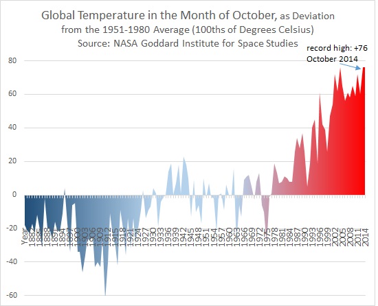
October proved to be one of the hottest months in recent times.
South America is covered in a layer of ice that is about 2.2 kilometers (1.4 miles) thick. A continental landmass with rocky mountains, volcanoes, and sizable canyons that humans have carved out over millions of years is beneath this ice. This is different from the Arctic in the Northern Hemisphere.
There are decades’ worth of satellite data and radar surveys that have made it possible to see the “lumps and bumps” of the long-lost bedrock.
It is one of the most complete maps of Antarctica, which is the world’s southernmost continental landmass.
The project was a huge undertaking that involved 19 research organizations from around the world, such as NASA, the National Science Foundation, the University of California Irvine, the British Antarctic Survey, the National Natural Science Foundation of China, the Australian government’s Cooperative Research Centres Program, and many more. It was published in 2019.
The map is interesting to look at, like using X-ray glasses to see inside a continent covered in ice. But it could also be used in science. Researchers can use the map’s data to learn a lot about Antarctica’s geographical mysteries, such as the continent’s shape and the future of its unstable ice sheets.
The canyon below the Denman Glacier was much bigger than I thought it would be from the map. Denman Trough, which is full of ice, is the deepest place on continental Earth. It is 3,500 meters (11,500 feet) below sea level.
“Older maps showed a canyon that was shallower, but that wasn’t possible; something was missing.” We know how much ice flows through the canyon because of the principle of conservation of mass. Based on our calculations, the canyon is 3,500 meters below sea level, making it the deepest place on land. In 2019, Mathieu Morlighem, an associate professor of Earth system science at the University of California, Irvine, said, “Because it’s not very wide, it has to be deep for that much ice mass to reach the coast.”
Ice has been covering most of Antarctica for millions and millions of years, covering more than 97% of the continent. There are almost 4.9 kilometers (3 miles) of ice at its thickest point, which is the height of six Burj Khalifas stacked on top of each other.
The land is very harsh, though, and ice is only one part of it. One less well-known fact about Antarctica is that it often erupts in volcanoes. In 2017, one study found 138 volcanoes in West Antarctica alone. Eight or nine of the volcanoes in Antarctica are thought to be active, even though most of them are not active. Mount Erebus is one of the most dangerous volcanoes in Antarctica. It is the southernmost active volcano on Earth and the tallest active volcano in Antarctica, with a peak that is 3,794 meters (12,448 feet) high.
It’s simple to picture Antarctica as a cold and, dare we say it, dull ice cube at the Earth’s core. But if you look more closely, you’ll see that it’s a world that is always changing and is full of secrets and strange stories.
Environment
Hurricane Beryl sets a new record for the season’s first hurricane, and officials warn of danger
Beryl is the first named hurricane of the Atlantic season this year. It has already made history before it even got to the Caribbean this morning, and officials say it looks like it will keep doing so.
When does the Atlantic hurricane season start? It starts on June 1 and ends on November 30. The first named hurricane usually happens in early to mid-August, and the first major hurricane (Category 3 or higher) usually happens between late August and early September.
Hurricane Beryl has already gone against the flow twice. A tropical storm gave it its start in late June, on Friday, the 28th. Second, it quickly became a major hurricane. On Sunday, its strong winds made it a Category 4 storm, making it the earliest storm of that strength to ever form in the Atlantic.
An advisory from the National Hurricane Center this morning said that Beryl will still be an “extremely dangerous” hurricane when it hits land in the Caribbean, even though it has weakened back down to Category 3.
“Hurricane-force winds, a life-threatening storm surge, and damaging waves could be very bad when Beryl goes over parts of the Windward Islands. St. Vincent and the Grenadines and Grenada will have the highest risk of the core starting later this morning,” the center said.
The storm’s strongest sustained winds are now estimated to be around 195 kilometers per hour (120 miles per hour). Winds that are that strong can uproot trees and do a lot of damage to even well-built homes.
The National Hurricane Center also said that the storm surge could raise water levels up to 1.8 to 2.7 meters (6 to 9 feet) above normal tide levels. This would bring “large and destructive” waves to coastal areas.
With 7.6 to 15.2 centimeters (3 to 6 inches) of possible rain, it’s easy to see why people in the Caribbean islands that will be hit by the hurricane first are being told to get ready as much as they can.
If your home is unsafe or could suffer damage from flooding or wind, stay put or move to a safe place. Food, water, and medicine should be kept safe for at least seven days in containers that won’t leak. Drains outside should be clear, and any loose items should be safely in place by now. “Put sandbags by all of your home’s doors,” the Trinidad and Tobago Meteorological Service warned early Monday morning.
It’s going to stay a “powerful hurricane” even after Beryl moves across the Caribbean Sea and over those first islands.
The damage from this hurricane is already clear, but it might not be the only one this year. The National Weather Service of the National Oceanic and Atmospheric Administration said in May that the 2024 hurricane season would be “extraordinary,” with four to seven major hurricanes possible.
Environment
The US is expected to have a record-breaking heatwave this week, with temperatures rising to very high levels
This week, it looks like it will be very hot in the US because the first big heatwave of the season is starting. During the first half of the week, it could get as hot as all-time highs in parts of the Midwest, Great Lakes, Northeast, and Mid-Atlantic. Extreme temperatures that will last for so long in some places haven’t happened in decades.
From the Ohio Valley to the Northeast, many daily high-temperature records and even some monthly records for June could be broken. High temperatures in some places are expected to reach up to 40.5 °C (105 °F).
Record-breaking #heat is forecast to expand from the Midwest and Great Lakes to the Northeast this week, potentially lingering through early next week. The duration of this heat wave is notable and potentially the longest experienced in decades for some locations. pic.twitter.com/4nJ1PS4qih
— NWS Weather Prediction Center (@NWSWPC) June 16, 2024
US residents will also have to deal with heavy rain, flash flooding, snow, and storms in different parts of the country. High temperatures aren’t the only weather problem that will happen.
The National Weather Service (NWS) says that in the new week, there will be “heavy wet snow across the northern Rockies.” Deep tropical moisture is also expected to move ashore across the Gulf Coast States, which could mean heavy rain. This danger goes all the way to the upper Midwest, where flash flooding and a few big storms are likely to happen.
The heatwave will now move from the central Plains to the Great Lakes, the Ohio Valley, and the Northeast today. It will stay in the Northeast through the middle of the week, according to the most recent report from the NWS’s Weather Prediction Center.
Over the next few days, a low-pressure system is expected to move across the central High Plains and get stronger as it moves toward and reaches the upper Midwest. The Weather Prediction Center says that “a heat wave is quickly emerging” ahead of this low-pressure system.
The heat will move into the Northeast by Tuesday. As far north as Vermont and New Hampshire, high temperatures will reach well into the 90s [90°F/32°C]. Some places in the middle of New England could see temperatures above 100 °F (38 °C) by Wednesday afternoon. In some places, this would be a daily record high.
Axios says this means that by Sunday, the air will have reached or been above 32°C (90°F) in 268 million places.
In the Four Corners region of the southwestern US, on the other hand, “critical fire danger conditions are anticipated today under persistently dry conditions.”
As the NWS points out, heat is the main cause of weather-related deaths in the US. Because of this, they want people to take the heatwave seriously and be careful, especially older people, pregnant women and babies, and people who already have persistent health problems. See the NWS’s helpful guides for tips on how to stay safe in the heat.
- Gadgets10 years ago
Why the Nexus 7 is still a good tablet in 2015
- Mobile Devices10 years ago
Samsung Galaxy Note 4 vs Galaxy Note 5: is there room for improvement?
- Editorials10 years ago
Samsung Galaxy Note 4 – How bad updates prevent people from enjoying their phones
- Mobile Devices10 years ago
Nexus 5 2015 and Android M born to be together
- Gaming10 years ago
New Teaser For Five Nights At Freddy’s 4
- Mobile Devices10 years ago
Google not releasing Android M to Nexus 7
- Gadgets10 years ago
Moto G Android 5.0.2 Lollipop still has a memory leak bug
- Mobile Devices10 years ago
Nexus 7 2015: Huawei and Google changing the game